GEODLL 25.55
Geodetic Software Development Kit for coordinate transformations ect
Program info

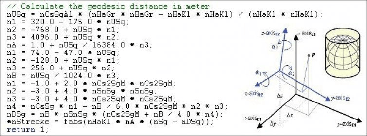

GeoDLL is a Geodetic Development Kit / Geodetic Function Library with worldwide 2D and 3D Coordinate Transformation, Datum Shift, Meridian Convergence and Extra Parameter with highest accuracy. Furthermore: Helmert and Molodensky Parameters, NTv2, HARN, INSPIRE, EPSG, Digital Elevation Model (DEM), distance and Time Zone calculations and much more. GeoDLL for geodetic and GIS development is available as 32Bit and 64Bit DLL and as C++ source code.
GeoDLL supports the development of geodetic software on various platforms by providing geodetic functions. Thus, geodetic functions of GeoDLL can be linked to programs written in C, C++, C#, Java, Pascal, Delphi, MS-Access, Visual Basic, Visual Objects or which are written in other programming languages.
The most important application of GeoDLL is to include professional Coordinate Transformations in own programs. These Coordinate and Reference Systems are supported: The current and historical Systems of all countries of Europe - The European ETRS89 systems forced by INSPIRE - The US and Canadian NAD, NTv2, HARN and SPCS Coordinate Reference Systems - The Coordinate Reference Systems of most countries of all continents - The Coordinate Reference Systems of Germany, Austria and Switzerland incl. NTv2 - The Geographic coordinates in different notations and Cartesian coordinates - Worldwide NTv2 gridfile supported Coordinate Transformations - Worldwide used numeric and alphanumeric Coordinate Systems - Most of EPSG supported Coordinate Reference Systems - ITRS annual realizations or WGS84 epochs for GPS measurements - WGS84 Coordinate Transformations in consideration of the continental drift - User defined Coordinate Systems, Reference Systems and earth ellipsoids - Meridian Convergence, Origin Center Meridian, Geographical Point Coordinates.
GeoDLL is written in C / C ++ and is developed using Microsoft Visual Studio. Thus very fast performance, compact code and high stability are assured.
Details
Extensions

No information available
The data will be available later.Awards

Related software
It is a geographic tool for converting UTM coordinates.
Convert coordinates from one coordinate system to another.
Coordinate reference system that best fits the shape of the earth as a whole.
Related stories
See all
3D modeling has become a salient and central feature of almost every entertaining and design field. Explore it with the best applications by yourself.

Microsoft's Paint 3D is an awesome application and despite its name, isn't actually that similar to Paint we all used. Here's everything you need to know about it.

Microsoft will deprecate Paint to make way for its successor: Paint 3D. The tool will still be available but no longer installed by default on Windows.